


Railway line
Detailed map
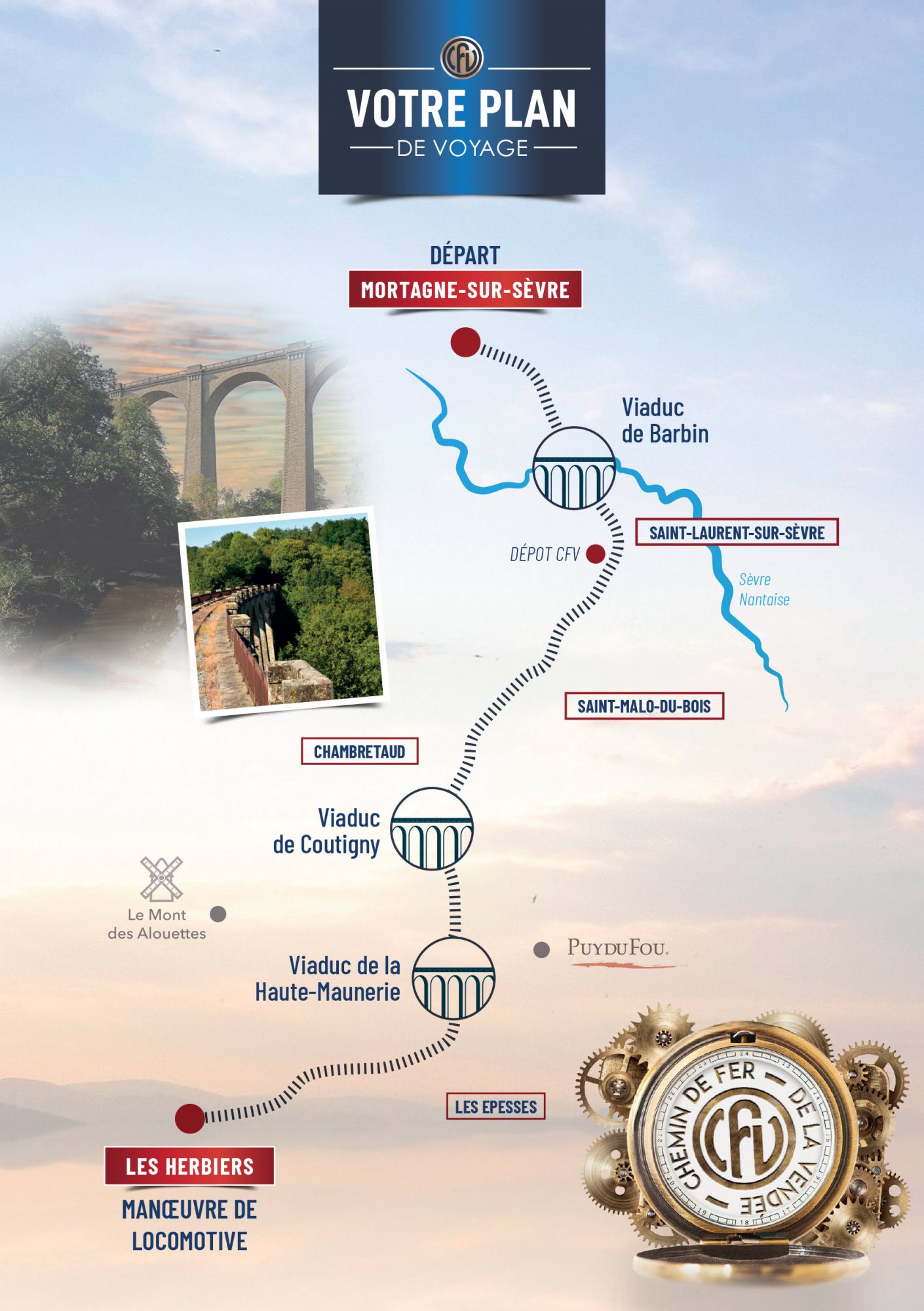
Description
Mortagne-sur-Sèvre (the station is 129 m above sea level) is still on the Choletais plateau; Les Herbiers (the station is 120 m above sea level) is on the great Vendée plain. These two towns are 15 km apart by road and 22 km apart by rail.
Between the two stand the Monts de Vendée (or Heights of Gâtine or Gâtine of Vendée), an extension of the Armorican massif south of the Loire. Their highest point is Saint Michel Mont Mercure, at 285m.
Crossing this small chain of hills explains the difficult profile of the line: in a few kilometers you have to climb almost 70 m. The gradients reach 15‰, which is considered a difficult climb for railways. These difficulties are overcome thanks to three viaducts (Barbin, Coutigny, Haute Maunerie), but also with the help of multiple small bridges, embankments, trenches, curves and tight counter-curves.
Leaving Mortagne-sur-Sèvre, the line follows the undulations of the Choletais plateau, to reach the Sèvre Nantaise valley, which it crosses via the Barbin viaduct (135 m above sea level).
The line begins its first steep ramp, in a deep trench cut into the rock, to reach Saint Laurent-sur-Sèvre (159 m above sea level). After the station landing, the line continues to climb over a first hill before descending into a small valley occupied by a stream, the Blanc, which flows into the Sèvre Nantaise.
Once you have crossed the stream, the climb begins again to Chambretaud station (at an altitude of 177 m). Chambretaud was the only commune in France, until 1980, which did not celebrate July 14, in memory of the massacres of 1793, during the Vendée Wars.
After levelling out at the station, the line continues to climb until it reaches the threshold where it crosses the Monts de Vendée. This crossing takes place in a deep trench crossed by a road bridge. This road bridge marks the highest point on the line at an altitude of 190 m: it is known as the bridge of sighs, because once crossed, the driver's work becomes less tiring.
The line descends towards the Cotigny viaduct which crosses a deep valley invaded by a pond. You can see, on the left, at the top of the hill, the windmills wings of the Puy du Fou castle. Then the line crosses a valley via the Haute-Maunerie viaduct, before arriving at Les Epesses station (155 m above sea level). The station is on a level and almost 3 km from the village.
The line continues down towards Les Herbiers, where it reaches the plain. It leaves on the left a wide view of Saint-Michel Mont Mercure, and on the right we see the Mont des Alouettes (230 m) and its mills, the scene of the Vendée Wars.
Mortagne-sur-Sèvre is 10 km from Cholet on the D160 towards La Roche-sur-Yon. Les Herbiers is 25 km from Cholet in the same direction.